-1.png?width=5230&height=1198&name=unnamed%20(4)-1.png "Wayne Stiles")

When people picture Jerusalem, they usually think of the historic Western Wall, or the Old City, or the Temple Mount crowned with the Golden Dome of the Rock.
But most folks are surprised to learn that the original city of Jerusalem lay just south of the Temple Mount on a small spur of land that encompassed about only ten acres.

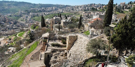
(Photo: City of David seen from the Observation Platform. Courtesy of the Pictorial Library of Bible Lands)
Crammed with houses and punctured with archaeological digs, the original area of Jerusalem looks much different today than it did three thousand years ago when King David conquered it.
But you can still get a sense of its drama.
Let me show you.
Jebus becomes Jerusalem, the City of David
After Israel crowned David king of all twelve tribes, he moved his capital city from Hebron—located in his own tribe of Judah—to Jerusalem in the tribe of Benjamin.
Jerusalem took a number of other names throughout history. In fact, the account of David conquering Jerusalem mentions three other names in one verse—Jebus, Zion, and the City of David (1 Chronicles 11:5).
Moving the capital to Jerusalem showed remarkable wisdom on David’s part.
- A city yet unconquered by the Hebrews meant that Jerusalem represented neutral territory.
- Even though it sat in Benjamin, no tribe would have felt necessarily proud or jilted.
The City of David Visitor’s Center features a 3-D film—very well done—that provides a helpful overview of the city’s history.
Watch it here:
The Steep Slopes—David’s Strength and Weakness
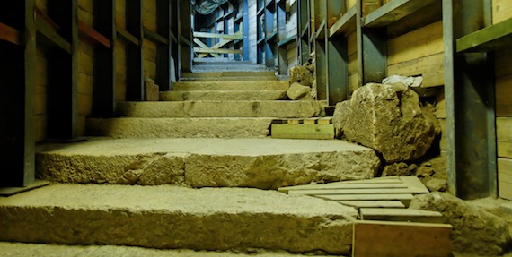
The best way to view the area is to ascend the stairs just inside the entrance to the Visitor’s Center and stand atop the observation platform.
[slideshow id=47]
(All pics courtesy of the Pictorial Library of Bible Lands)
Flanked on two sides by steep valleys, the ancient City of David enjoyed a tremendous military advantage—making it relatively easy to defend.
Ironically, however, the steep slopes also proved David’s undoing.
- From the vantage on the observation platform, it’s plain to see how David easily could have looked down over the homes built on the slope below him and seen Bathsheba bathing that fateful evening.
- The modern-day village of Silwan, just across the Kidron Valley from the City of David, has its homes constructed in a similar way.
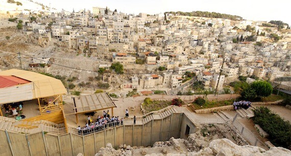
(Photo: The village of Silwan, across from the City of David. Courtesy of the Pictorial Library of Bible Lands)
Archaeology in the City of David
Today, this part of Jerusalem retains the name, “The City of David,” and offers an archeological connection to the monarch.
- At the summit of what is called “Area G,” a stepped-stone structure represents one of the largest Iron Age constructions ever excavated, dating from the 12th Century BC.
- Many archeologists believe it likely supported the palace of King David, the ruins of which are partially visible after descending some stairs.
In 1838 Edward Robinson discovered Hezekiah’s Tunnel—a marvelous find and one of the few archaeological discoveries visitors can interact with. The related Siloam Inscription was discovered later in 1880.
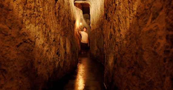
(Photo: Hezekiah’s Tunnel. Courtesy of the Pictorial Library of Bible Lands)
Modern archaeological excavations began in the late 1970s and continue today under the capable eyes of Ronny Reich and Eli Shukrun. If you’d like a good overview of the site’s archaeology, pick up Reich’s excellent volume, Excavating the City of David.
Two relatively recent finds are nothing short of thrilling.
- In 2004, Reich and Shukrun found the first-century Pool of Siloam (known as the lower pool).
- They also recently discovered a road—the Siloam street—that led from this major water source up to the Temple Mount. First-century Jews would have used this road during their pilgrim feasts—most notably during Sukkot.
(Photo: Siloam street. Courtesy of the Pictorial Library of Bible Lands)
Arguing Over the Obvious
Not surprisingly, a number of archaeologists today express their doubts that the entire City of David ever was included in the original Jerusalem.
- But the conspicuous location of the Gihon Spring seems a hard fact to sidestep. Moreover, the discovery of Warren’s Shaft by Charles Warren in 1867 and the fortifications around the nearby Spring House reveal that the locals clearly made use of the spring in David’s day.
- It seems far more likely that this small area of land was the same place David conquered.
- The map below shows the location of the Gihon Spring to the City of David.
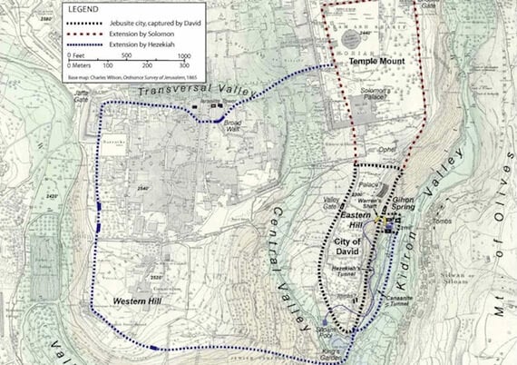
(Map of Old Testament Jerusalem, courtesy of Satellite Bible Atlas)
Jerusalem’s Expansion
Of course, the city expanded to the north during David’s time when he purchased the hill that would become the Temple Mount under Solomon’s rule.
- This area the Bible identifies as Mount Moriah, the place where Abraham bound his son Isaac in order to offer him to the Lord (Genesis 22:2; 2 Chronicles 3:1).
- During the time of Hezekiah, the city enlarged again to encompass the Western Hill in order to house and protect fleeing refugees from the northern tribes after their kingdom fell to Assyria.
The walls of Jerusalem have expanded and contracted through the centuries like the breathing of a living being.
Arguably the most important city in history had its infancy in an area that today hardly reflects its grandeur.
See The Holy Land In Person
Journey to the Bible Lands with Wayne Stiles. You will NEVER be the same! Learn more:

Tell me what you think: What lesson can you draw from the fact that Jerusalem’s place of significant beginning is today so obscured? To leave a comment, just click here.
Click here to leave a comment.
.jpg?width=350&name=Wayne-books-350wide%20(1).jpg)